EBC Trek Day 14 Monjo to Lukla
Posted on May 22, 2020, 12:37 pm
Monjo (2815m)
I pushed it from Dole to Monjo. It's a 6h50 walking (16 Km) and I arrived at Monjo yesterday before the sunset.
There is a handful of the lodge in Monjo. Despite in the high tourist season, I can easily find a place to stay up on my arrival and without booking in advance.
The lodge I stay located along the little river stream between the valley and face to the trekker road. So from time to time, when the porter passes through the village, the sound of the yak bells mix with the river flow and the singing birds makes a beautiful atmosphere.
The lodge veranda face to the mountain gives a green view to the village’s vegetable garden, two little tables, and some chairs installed on the veranda and I just sit there take a break to enjoy some hot black tea, and seeing the sunset.
Emm! I talk to myself: don't you think this is the paradise?
Fill your life with adventures, not things.
Have stories to tell, not stuff to show.
-author unknown
The temperature was not too cold at this altitude so I had a good sleep here.
|
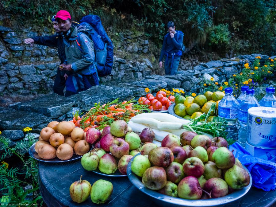
| Apples, Pear (Poire), carrot, and Turnip (Navet)... That villagers put on the small table in front of their house for sale |
Read More
EBC Trek Day 12-13 Gokyo-Dole-Namche Bazar-Monjo
Posted on February 16, 2020, 9:13 pm
Leaving Gokyo(4750m)
The Everest view from Gokyo Ri is only one of the many reasons for visiting Gokyo.
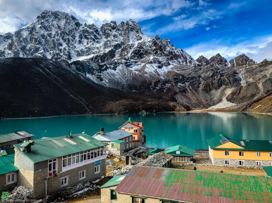
There are more than 7 lodges here, most of them are face to the lake, relaxing on the lodge patios or their sunrooms overlooking the rich turquoise, picturesque lake and the etched mountains above are considered reward enough by some.
The lake in front of the village called Gokyo Tso (it was written Tsho on some printed map which I believed mean lake); it's the world's highest freshwater lake system with an area of 43Ha and a 43M of maximum depth.
They said It was considered sacred by both Hindus and Buddhists. But you know? even it's a wonderful place but it does have its problems. The toilets are potentially polluting the lake - without visible impact yet, perhaps, but it is hard to work out how to improve this situation.
Standing in front of the lake; you will find on your left side Mt Phari Lapcha and Gokyo Ri on your right.
Phari Lapcha Peak is one of the most popular trekking peak climbing of Khumbu region at an elevation of 6017m of Mahalangur Himalayan Range.
|
| Gokyo Village and Gokyo Lake, view from Namaste Lodge. Behind the lake is the Phari Lapcha Peak with the elevation of 6017m. |
EBC Trek Day 10-11 Dzonglha to Dragnag to Gokyo
Posted on February 2, 2020, 12:10 pm
មកដល់ Dzonglha ពីល្ងាចមិញ ដើរផងរត់ផង ព្រោះ ហូបបាយរួចទើបបាន ចេញពី Gorakshep មក គឺម៉ោង ១ ថ្ងៃត្រង់ទៅហើយ, គេប្រាប់ខ្ញុំថា ត្រូវដើរប្រហែល ៥ ម៉ោង ទើបដល់ Dzonglha ដែលភូមិនេះ មានចម្ងាយ ប្រហែល ១១ គីឡូម៉ែត្រ ពី Gorakshep ។
បើប្រាប់គេ, ក៏គេអត់ជឿរ ព្រោះ ខ្ញុំជើងខ្លី តែ ដើរលឿន គឺដើរ អត់ហ៊ាន ឈប់ ព្រោះខ្លាចទៅដល់ យប់ ពិបាករកកន្លែងស្នាក់នៅ. មិនមែនអត់ឈប់សោះទេ ឈប់ដែរ ឈប់សំរាក់ តាមផ្លូវ តែ ២~៣ នាទីទេ
ចឹងហើយ ខ្ញុំ ប្រើពេលតែ ៣ ម៉ោងជាង ប៉ុណ្ណោះ (៣ ម៉ោង ៤៦ នាទី) ដើម្បី មកដល់ Dzonglha ។
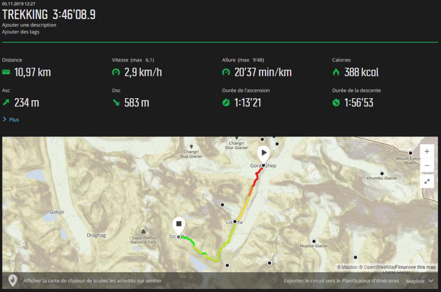
Dzonglha (4850m) which is 11 Km from Gorakshep (5 hours walk), this is a summer yak-herding station on the left, or south side of the miniature valley.
There are two lodges here, Green Valley lodge and Himalaya lodge, I arrived here yesterday, one the lodge was fully booked but luckily I fond a place to stay in the second one.
|
| GPS Trace from Gorakshep to Dzonglha |
ពេលដើរមក ម្សិលមិញហ្នឹង អត់បានថត់រូបទេ ថតបានតែ វីដេអូបន្តិចបន្ទួច, ព្រោះមកដល់ ពាក់កណ្តាលផ្លូវ ចុះអ័ព្វ មើល អី ឆ្ងាយមិនឃើញ , មើលឃើញប្រហែល ១០ ម៉ែត្រ ពីខ្លួន ប៉ុណ្នោះ គឺខ្ញុំពឹងទៅលើ GPS ទាំស្រុង ដើម្បីរកផ្លូវ តែសំណាងដែល ពេលមកដល់ផ្លូវបំបែកនៅ Loboche
ក៏បានជួប អ្នករកស៊ី ជញ្ជូនឥវ៉ាន, គាត់ក៏ត្រូវទៅ Dzonglha ដែល អញ្ចឹង ក៏ខំដើរតាមគាត់ គ្រាន់បានជាគ្នា ព្រោះដើរ យូរហើយ ជួបមនុស្សតែបីអ្នកគត់ ណាមួយ ចុះអ័ព្វ មើលផ្លូវ សឹងតែមិនឃើញ ។
នៅក្រោយខ្នង គាត់ មាន វ៉ាលីធំមួយ មានខ្សែរពាក់លើក្បាល ដើម្បីទ្រទំងន់ វ៉ាលីនោះ បើតាមស្មាន មិនតិចជាង ២០ គីឡូទេ តែគាត់ដើរលឿនជាងខ្ញុំទៅទៀត តាមមិនទាន់ ។
ម៉ោងប្រហែល ៥ ល្ងាច ទើបមកដល់, វាព្រលប់បន្តិចហើយ ភូមិនេះ មានផ្ទះសំណាក់ភ្នំ តែពីរប៉ុណ្ណោះ ។
|
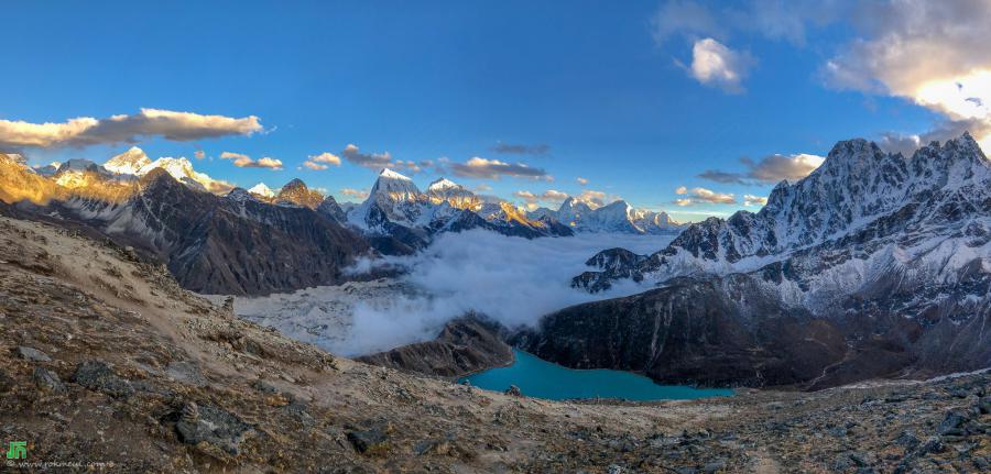
| Everest region, view from Gokyo Ri (5340m) |
EBC Trek Day 8-9 Gorakshep to Kala Pattar next day EBC and Dzonglha
Posted on December 31, 2019, 1:43 pm
មួយប៉ព្រិចភ្នែកសោះខ្ញុំ ដើរបាន ពាក់កណ្តាលផ្លូវហើយ មកដល់ពេលនេះគឺ ៨ ថ្ងៃគត់ ដែលខ្ញុំបានចេញ ពីរ Lukla
«លង់និងសម្រស់ ធម្មជាតិ ជួរភ្នំ ហ៊ីមម៉ាឡាយ៉ា (the Himalayas) ភ្លេចមើល ង៉ៃ ហ៊ឹម! ពេវេលាពិតជាលឿនមែន!»
ចម្ងាយ ផ្លូវសម្រាប់ថ្ងៃនេះ តែជាង ៥ គីឡូម៉ែត្រ ប៉ុណ្នោះ តែដោយសា ផ្លូវ ឡើង កាន់តែខ្ពស់ អុកហ្ស៊ីសែន នៅក្នុង បរិយាកាស់ កាន់តែតិច ដូច្នោះ ខ្ញុំដើរមិនបានលឿនទេ
អ្នកដែលរស់នៅតំបន់ នេះ ដើរ ដូចជាគ្នាន ហត់ អ្វីបន្តិចសោះ តែខ្ញុំវិញ ដើរឈប់ៗ ត្រូវចំណាយពេល ៤ ម៉ោងជាង ទើបបានទៅដល់ Gorakshep, (៤ម៉ោង ២៦នាទី ពី Loboche) ។
អ្វី ដែលគួរអោយរំភើបនោះគឺ EBC (Everest Base Camp) គឺវាស្ថិតនៅតែជាង ២ គីឡូម៉ែត្រ ពី Gorakshep គេអាចមើលវាឃើញ ពីចម្ងាយ ។
ក្នុងគំរោង ពេលមកដល់ Gorakshep ត្រូវយក ឥវ៉ានទុក នៅកន្លែងស្នាក់នៅ (Lodge) រួចទើប ដើរទៅ EBC, តែខ្ញុំគិតថាវាមិនមែនជាគំនិតល្អរនោះ ទេ បើដើរទៅ EBC ពេលនេះ (ម៉ោងប្រហែល ២ ថ្ងៃត្រង់)
ហើយ ថ្ងៃស្អែត្រូវងើបពីព្រឹក ដើរឡើង Kala Pattar ព្រោះសីតុណ្ហភាព ពេលព្រឹក ត្រជាក់ខ្លាំង (២៥ អង្សារ ក្រោមសូន្យ) ហើយ Kala Pattar នៅខ្ពស់ ជាង EBC ចឹងហើយ ឡើង Kala Pattar មុន ស្អែកព្រឹក ទើបទៅ EBC ។
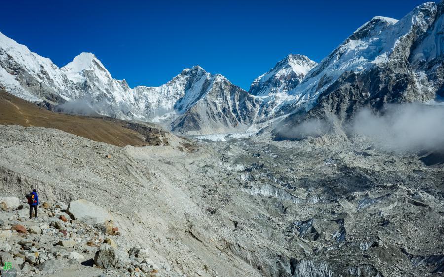
|
| ផ្លូវទៅ EBC, ដើរពី Gorakshep |
EBC Trek Day 6-7 acclimatize at Dingboche and heading to Loboche on the next day
Posted on December 22, 2019, 4:30 pm
Dingboche ស្ថិតនៅ រយះកំពស់ 4350 ម៉ែត្រ ភូមិនេះមាន ប្រជាជនរស់នៅច្រើនគួរសម, មានផ្ទះសំណាក់ (lodge or tea house) ប្រហែលជាង ២០ ស្ថិតនៅ ជ្រលងភ្នំ ចន្លោះ រវៀង Ama Dablam និង Nangkartshang, វាមានចម្ងាយ ប្រម៉ាន ជិត ៩ គីឡូម៉ែត្រ ពី Loboche ។
មុននឹងបន្តរដំនើរទៅ Loboche ភាគច្រើនគេស្នាកនៅ ភូមិនេះ ឬក៏ ភូមិមួយទៀតនៅជិតហ្នឹង (Pheriche) ចំនួនពីរថ្ងៃ ពោលគឺដើម្បី អោយរាងកាយ មានពេល គ្រប់គ្រាន់ អាចសម្របជាមួយ រយះកំពស់ ខ្ពស់ ព្រោះបរិមាណ អុកហ្ស៊ីសែន នៅក្នុង បរិយាកាស់នៅទីនេះ ថយចុះមកនៅប្រម៉ាណ តែ 50 ភាគរយ ប៉ុណ្នោះ ។
ការស្នាក់នៅ មួយថ្ងៃ ឬក៏ ពីរថ្ងៃបន្ថែមនេះ ភាសារអង់គ្លេល គេថា Acclimatize Day ។
ថ្ងៃនេះត្រូវ ដើរឡើងទៅ Nangkartshang Peak ដែលមានកំពស់ជាង 5000 ម៉ែត្រ ។
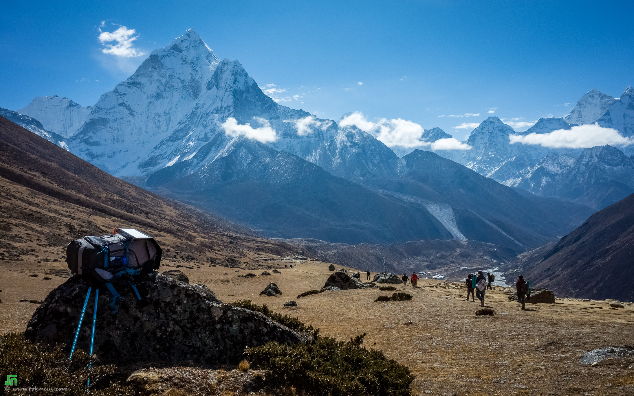
|
| នៅតាមផ្លូវ ទៅ Loboche |
Blog Categories
Blog Archive
- 2023-May (1)
- 2023-February (1)
- 2020-October (1)
- 2020-May (1)
- 2020-February (2)
- 2019-December (5)
- 2019-November (1)
- 2018-July (1)
- 2017-December (1)
- 2017-November (1)
- 2017-June (1)
- 2016-September (5)
- 2016-August (3)
- 2016-June (1)
- 2015-September (1)
- 2015-May (1)
- 2015-February (2)
- 2014-December (1)
- 2014-November (2)
- 2014-September (3)
- 2014-August (1)
- 2014-June (1)
- 2014-May (1)
- 2014-March (1)
- 2013-December (2)
- 2013-October (2)
- 2013-July (1)
- 2013-June (3)
- 2013-May (4)
- 2013-March (1)
- 2012-December (2)
- 2012-November (1)
- 2012-October (1)
- 2012-September (2)
- 2012-August (2)
- 2012-July (2)
- 2012-June (1)
- 2012-May (2)
- 2012-March (2)
- 2012-February (2)
- 2012-January (5)
- 2011-December (2)
- 2011-November (4)
- 2011-October (5)
- 2011-September (2)
- 2011-August (1)
- 2011-June (2)
- 2011-May (1)
- 2011-April (9)
- 2011-March (3)
- 2011-February (12)
- 2011-January (16)
- 2010-December (17)
- 2010-November (6)
- 2010-October (10)
- 2010-September (8)